INSPIRE framework defines different types of network services responsible mainly for providing spatial data to the users. The most popular are:
- view services that allow the users to display the data and
- download services that allow downloading copy of the spatial datasets.
From the usability perspective, out of these two view services are less complicated. They can be utilized in a greater number of the client application and they are in most cases causing fewer compatibility issues. From the data provider perspective, they are usually easier to set up.
Therefore, it is a good practice to make spatial data downloadable via view services as a supplement to standard download services. A solution utilized successfully in Poland uses GetFeatureInfo request of WMS service to deliver a user:
- metadata describing a downloadable subset of a dataset, URL (link) allowing to download a subset of a dataset.
Normative Reference
The solution implemented in Poland is relatively new. Therefore, there are no references available in English.
References
Geoportal Krajowy – Pobieranie danych (2020) accessed on 19th of September 2020 from https://www.youtube.com/watch?v=7VsYSZxEkqE&feature=youtu.be
Relevance & expected benefits
The proposed GP goes beyond the requirements of the IRs and TGs to improve the usability/usefulness of the infrastructure.
View WMS services are in general easier to set up and maintain than download services. Therefore, from the data providers perspective following proposed GP allows to quickly publish network services that provide downloadable spatial datasets.
Users, especially non-experienced users, in general, are dealing better with view services comparing to download services. View services like WMS are much more intuitive and thus easier to operate with, they are also supported by grater amount of client applications. Therefore, it is very likely that users if given a chance will utilize view services in order to download spatial datasets.
Proposed GP hides INSPIRE complexity related to metadata and network services and provide users with a simple, intuitive solution allowing them to download the data.
Outcome
Potential users via WMS services should have access to basic metadata describing spatial datasets and should be able to download the dataset or its subset by pointing to a link delivered by GetFeatureInfo response.
Evidence
From 31st of June 2020 amendment of a Polish geodetic and cartographic law has entered into force, as a result, most of the datasets managed by geodetic and cartographic service have been opened. The newly opened datasets have been published for download via WMS services utilizing GP described in the document. The datasets are downloadable without any restrictions and limitations. Currently following WMS download services are available:
- orthoimagery o based on currency https://mapy.geoportal.gov.pl/wss/service/PZGIK/ORTO/WMS/SkorowidzeWgAktualnos ci
o based on pixel size https://mapy.geoportal.gov.pl/wss/service/PZGIK/ORTO/WMS/SkorowidzeWgRozdzielc zosci
- digital elevation model (DEM) https://mapy.geoportal.gov.pl/wss/service/PZGIK/NMT/WMS/SkorowidzeWUkladzieKRON86
- digital terrain model (DTM) https://mapy.geoportal.gov.pl/wss/service/PZGIK/NMPT/WMS/SkorowidzeWUkladzieKRON86
- LIDAR data https://mapy.geoportal.gov.pl/wss/service/PZGIK/DanePomNMT/WMS/SkorowidzeWUkladzieK RON86
- basic geodetic network pointshttps://integracja.gugik.gov.pl/cgibin/PodstawowaOsnowaGeodezyjna
- register of administrative units and addresshttps://integracja.gugik.gov.pl/cgibin/PanstwowyRejestrGranic
- general geographic database (250k)https://integracja.gugik.gov.pl/cgi-bin/BDOO
- topographic database (10k)https://integracja.gugik.gov.pl/cgi-bin/PobieranieBDOT10k
- 3D buildings modelshttps://integracja.gugik.gov.pl/cgi-bin/ModeleBudynkow3D
The solution uses WMS service, so it can be utilised in any application adopting WMS standard. In typical use case scenario user via WMS client application points out on the map location for which data should be downloaded. GetFeatureInfo request is sent to the server, the response returns metadata and links to the dataset subset covering indicated location. Then the user clicks on the link to an appropriate subset and downloads it. The spatial extend of a subset may be limited by administrative boundaries e.g. in case of the register of administrative units and address or map sheet index e.g. in case of orthoimagery. Polish national Geoportal implementation example of GP is presented at YouTube themovie (English subtitles are available).
Although the solution has been implemented in Poland just recently it seems to be very successful. First of all, there are many custom tools available working on top of WMS services to automatize the process of downloading the spatial data. Some of these tools are available for free as QGIS extensions e.g. pobieracz danych GUGiK or BDOT10k_GML_SHP. Some require proprietary software e.g. FME.
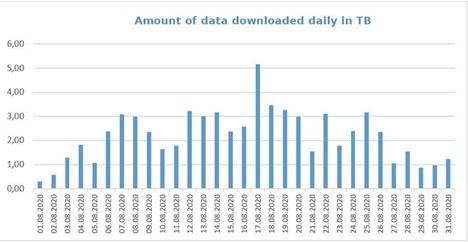
Figure 1 presents statistics of GUGiK data downloaded daily in August 2020. Altogether during the first month after the opening over 68 TB of spatial data were downloaded by the users.
Figure 1 Amount of data downloaded daily in TB
Limitations:
Subsets of the datasets for download have to be available and regularly updated at network locations accessible from the Internet.
IKB Area:
Implement
IKB Component:
Metadata
Network Services
Good Practice Type:
Endorsed

